1 / 1
Product Overview
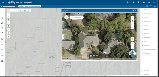
Eagleview for Trimble Unity Maintain seamlessly integrates Eagleview's high-resolution oblique and orthogonal aerial imagery into Trimble Unity Maintain, enhancing workflows for asset management, permitting, and field inspections. With industry-leading 1-inch resolution imagery, users can remotely assess infrastructure, verify site conditions, and track landscape changes over time. API-based access ensures seamless integration without the need for individual logins, simplifying deployment and security. By bringing precise, measurable aerial data into Trimble environments, Eagleview empowers public sector and infrastructure teams to improve efficiency, enhance decision-making and reduce the need for on-site visits – all from the convenience of their desktop.
Features
Remote Site and Asset Inspection
Access high-resolution oblique and orthogonal imagery within Unity Maintain to remotely inspect infrastructure, properties, and assets with precision. Reduce field visits and enhance decision-making by verifying conditions from the desktop.Seamless integration with Trimble Unity Maintain
Eliminate the need to switch between multiple platforms - Eagleview imagery is embedded directly into your Trimble environment. API-based access ensures a smooth, secure and scalable solution for GIS, permitting and asset management workflows.Historical and Change Detection Analysis
Compare current and historical aerial imagery to track changes over time, verify compliance, and support planning initiatives. With Eagleview's frequent capture cycles, stay ahead of infrastructure changes and environmental shifts.
Categories
Permitting
Permitting
Reality Capture
Reality Capture
Support
View Full Support and ResourcesPermitting

Eagleview + Unity Maintain
The power of 1-inch imagery, now in Unity Maintain
Developer: Eagleview
- Works with Trimble Unity Maintain
Attention
Please get in touch with your account owner for assistance. If you wish to make a purchase, we recommend signing out and creating a personal account.
